PICTORIAL OF SOME OF THE MORE THAN 1,000 PYRAMIDS IN MESO/CENTRAL
- Peggy D. Adams-Middleton
- Jan 1, 2019
- 13 min read


Smithsonian Magazine lists that there are more than 100 pyramids in Egypt, while there are more than 1000 pyramids in Central America, according to World-Pyramids.com. The pyramids of Central America, or more appropriately, the cultural area of Mesoamerica, were built as early as 3rd or 6th century.
The Great Pyramid of Cholula:
The Great Pyramid of Cholula stands 66 meters tall and its base covers more than 200,000 square feet—more than four times the size of the base of the Great Pyramid of Giza in Egypt. Or as this helpful Business Insider video notes for us metrically-challenged Americans, even Michael Phelps would get tired swimming around it:
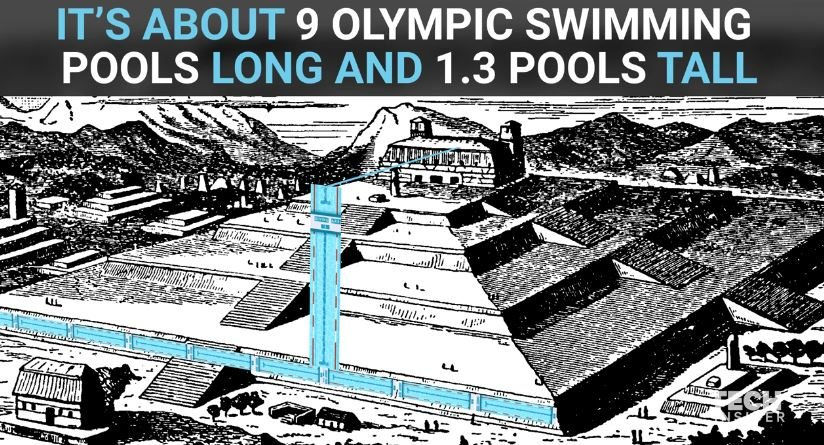
Of course, the fact that the Spanish—also famed destroyers of things they found— never uncovered the pyramid is one reason it still stands today. The Spanish leveled most of the other religious structures in the area, but the pyramid went unnoticed until locals re-discovered it in 1910. Today visitors can explore some of the excavated tunnels and visit the on-site museum to learn more about this ancient wonder. As long as you know where to look.
Cholula - Youtube
Pyramid of the Sun

For those unfamiliar, Teotihuacán is old. Very, very old. It was built around 100 BC and collapsed a thousand years later in 550 AD due to invasion or famine (no one really knows). Unlike the pyramids in Egypt, Teotihuacan wasn’t just a religious temple. It was a city, and a large one. At its highest, this mysterious metropolis reached a peak population of 200,000 people.
Most other famous temples in Mexico were either built by the Aztecs or the Mayans, but no one knows who built Teotihuacán. One thing all experts can agree on is that the Aztecs named the city Teotihuacán, meaning ‘place of the gods’.
In 1971, archeologists found a secret tunnel inside the pyramid that led to more than 50,000 ritual objects and a set of chambers. Experts believe that these chambers were used for rituals and maybe even as a burial-place for the city’s elite.
For the people of Teotihuacán, the Pyramid of the Sun had a strong religious significance. And it continues today more than 2,000 years later. Every year on March 21st, visitors flock to the top of Mexico’s Pyramid of the Sun to celebrate the spring equinox.
Rendering of Yucatan Pyramid City


OLMEC
The Olmecs were the earliest known major civilization in Mesoamerica following a progressive development in Soconusco. They lived in the tropical lowlands of south-central Mexico, in the present-day states of Veracruz and Tabasco.


The Olmec civilization developed in the lowlands of southeastern Mexico between 1500 and 400 BC. The Olmec heartland lies on the Gulf Coast of Mexico within the states of Veracruz and Tabasco, an area measuring approximately 275 kilometres (171 mi) east to west and extending about 100 kilometres (62 mi) inland from the coast. The Olmecs are regarded as the first civilization to develop in Mesoamerica and the Olmec heartland is one of six cradles of civilization worldwide, the others being the Norte Chico culture of South America, the Erlitou culture of China's Yellow River, the Indus Valley Civilization of the Indian subcontinent, the civilization of ancient Egypt in Africa, and the Sumerian civilization of ancient Iraq. Of these, only the Olmec civilization developed in a lowland tropical forest setting.
The Olmecs were the first inhabitants of the Americas to construct monumental architecture and to settle in towns and cities. They were also the first people in the Americas to develop a sophisticated style of stone sculpture. In the first decade of the 21st century evidence emerged of Olmec writing, with the earliest examples of Olmec hieroglyphs dating to around 650 BC. Examples of script have been found on roller stamps and stone artefacts; the texts are short and have been partially deciphered based on their similarity to other Mesoamerican scripts. The evidence of complex society developing in the Olmec heartland has led to the Olmecs being regarded as the "Mother Culture" of Mesoamerica, although this concept remains controversial.


Attire of Aztec/Mayan/Olmec

Palenque (Chiapas) Pyramid - See Temple on top.

Tribal Jungle Music - Mayan Pyramids - Youtube
Tikal Pyramid in Guatemala
Tikal Guatemala. Day and Night. Mayan Ruins & Wild Animals - Youtube
Lamanai, Belize - Mayan Ruins

The Pyramids of Mexico - Youtube
While we are familiar with Pyramids in Egypt and Mexico, the truth is that these structures are not confined to these two countries. There are more than 1000 pyramids in central America alone. There are 300 Pyramids in China and over 200 Pyramids in Sudan. Egypt boasts around 120 Pyramids.

Headdress Aztec/Mayan Only Important People wore Headdress


Chichen Itza
Chichen Itza contains many fine stone buildings in various states of preservation; the buildings were formerly used as temples, palaces, stages, markets, baths, and ball courts.

One of the most famous pyramid sites can be found at Chichen Itza, its name meaning "At the mouth of the well of the Itza (people)". Although this was the name for the site in pre-Columbian times, it is also referred to in the ancient chronicles as Uucyabnal, meaning "Seven Great Rulers". It is a large pre-Columbian archaeological site built by the Maya civilization located in the northern center of the Yucatan Peninsula, in the Yucatan state, present-day Mexico.

Diagram of Chichen Itza

Mexico - Chichen Itza - Youtube
At dusk on 21 March and 22 September, days before the start of spring and fall equinoxes, in the north stairway of the Castillo de Chichen Itza a solar projection of a Serpent of LIGHT appears consisting of seven inverted triangles of light. It is is formed as a result of the shadow cast by the nine platforms of the pyramid, which get the sun.
The phenomenon at Chichen Itza is seen in all its glory as the image of the serpent of light and dark triangles majestically appear down the stairs north of the Castle.
First, the first shadows of the higher bodies of the pyramid begin to draw isosceles triangles that make up the body of the feathered serpent. Later, the shadow gradually moves towards snake-shaped head located at the bottom of stairs.
The vision is of a serpent god Kukulkan, the most important deity of the Mayas, who descends slowly from the top to the bottom of the pyramid. This view is approximately 30 to 40 minutes, moment when all gathered there waiting to receive cosmic energy and recharge it.
See the Observatory.


The above and below is a Rendering drawing of the Mississippi Mound Builders Culture - Similar to Mesoamerica Pyramids


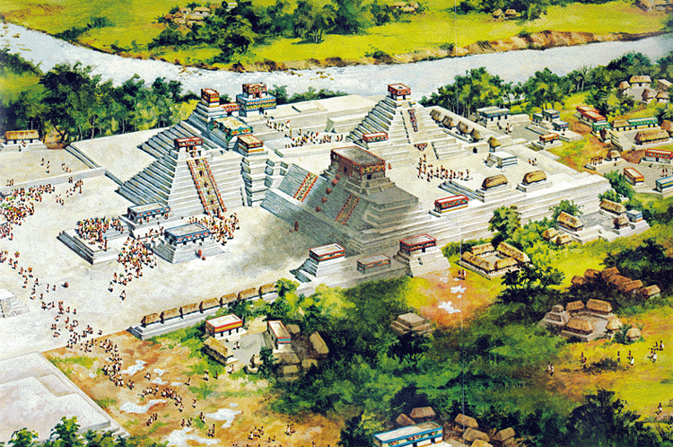
Mayan/Aztec/Olmec Cities
Rendering of the Mississippi Culture - Cahokita

Serpent - Mesoamerica - Serpents were common in Egypt

The Great Serpent Mound is a 1,348-foot (411 m)-long,[3]three-foot-high prehistoric effigy mound on a plateau of the Serpent Mound crater along Ohio Brush Creek in Adams County, Ohio.

A Rendering of Temple Pyramids in Mesoamerica

The Indigenous population before the conquest of Columbus

Interesting Artifact - You decide.

.

Tulum
Tulum (Spanish pronunciation: [tuˈlum], Yucatec: Tulu'um) is the site of a pre-Columbian Mayanwalled city which served as a major port for Coba, in the Mexican state of Quintana Roo.[1]The ruins are situated on 12-meter (39 ft) tall cliffs along the east coast of the Yucatán Peninsula on the Caribbean Sea in the state of Quintana Roo, Mexico.[1] Tulum was one of the last cities built and inhabited by the Maya; it was at its height between the 13th and 15th centuries and managed to survive about 70 years after the Spanish began occupying Mexico.
Tulum - Youtube
Tulum Ruins


Renderings of Aztec/Mayan Cities


Aztec Headdress

Pyramid of Mayan, Uxmal, Yucatan, Mexico

Uxmal - Youtube
Tula
Tula, also called Tollan, ancient capital of the Toltecs in Mexico, it was primarily important from approximately AD 850 to 1150. Although its exact location is not certain, an archaeological site near the contemporary town of Tula in Hidalgo state has been the persistent choice of historians.
The main temple pyramid and its associated structures epitomize the stylistic characteristics of Tula architecture. Though small, the pyramid was highly decorated. The sides of the five terraces were covered with painted and sculptured friezes of marching felines and canines, of birds of prey devouring human hearts, and of human faces extending from the gaping jaws of serpents. A stairway on the southern side led to a highly ornamented two-room temple at the summit. The front room was supported by four columns in the form of erect, stiffly posed warriors, each 15 feet (4.6 metres) high and adorned with a series of highly specific body ornament and accoutrements representative of the Tula style. Attached to the southern base of the pyramid was another feature of Tula architecture—great colonnaded masonry hallways with flat roofs supported on scores of masonry columns.
Warriors

Map of Aztec/Mayan/Olmec Countries


Pyramids Caracol, Nakum & Naranjo - Youtube

El Tajin Tajin Mayan Aztec Mexico Pyramid Inca
an Aztec Mexico Pyramid Inca

The site is located in Mexico in the highlands of the municipality of Papantla in modern-day Veracruz, not far from the city of Poza Rica, which lies northwest of the port and city of Veracruz. The city is set in the low rolling mountains that lead from the Sierra Madre Oriental to the Gulfcoast near the Tecolutla River. In ancient times, this city was located in the northeast corner of what is called Mesoamerica, and controlled an area from between the Cazones and Tecolutla Rivers to the modern state of Puebla. The main city is defined by two streams which merge to form the Tlahuanapa Arroyo, a tributary of the Tecolutla River. These two streams provided the population’s potable water. Most of the buildings are at the southern end, where the land is relatively flat and the two streams converge. The site extends to the northwest where terraces where constructed to place more buildings, mostly for the city’s elite. However the city also had communities located on the hills east and west of the main city, with mostly lower-class dwellings. Total site extends for 1,056 hectares (4.08 sq mi).
The area is rainforest, with a hot wet climate of the Senegal type. Average temperature for the year is 35 °C with hurricanes possible from June to October. It is also affected by a weather phenomenon called “nortes.” These are cold fronts with winds that come from the north and down the Tamaulipas and Veracruz coasts. The site has no major settlements located next to it. Surrounding it are tobacco fields, banana plantations, apiaries and vanilla groves. The closest settlement of any real size is Papantla.
When it was rediscovered by officialdom in 1785, the site was known to the local Totonac, whose ancestors may also have built the city, as El Tajín, which was said to mean “of thunder or lightning bolt”. Related to this is their belief that twelve old thunderstorm deities, known as Tajín, still inhabit the ruins. However, a series of indigenous maps dating from the time of the Spanish conquest, found in nearby Tihuatlan and now known as the Lienzos de Tuxpan, suggest that the city might then have been called “Mictlan” or “place of the dead”, a common denomination for ancient sites whose original names have been lost. This name also appears in the Matricula de Tributos, a surviving Aztec tribute record, which later formed part of the Codex Mendoza. This may therefore be linked to another Totonac meaning claimed for El Tajín: “place of the invisible beings or spirits”.
Chronology studies at Tajín and nearby sites show that the area has been occupied at least since 5600 BCE and show how nomadic hunters and gatherers eventually became sedentary farmers, building more complex societies prior to the rise of the city of El Tajin. The pace of this societal progression became more rapid with the rise of the neighboring Olmec civilization around 1150 BCE, although the Olmecs were never here in great numbers. It is unclear who built the city. Some argue in favor of the Totonacs and the Xapaneca; however, there is a significant amount of evidence that the area was populated by the Huastec at the time the settlement was founded in the 1st century CE Monumental construction started soon after and by 600 CE, El Tajín was a city. The rapid rise of Tajin was due to its strategic position along the old Mesoamerican trade routes. It controlled the flow of commodities, both exports such as vanilla and imports from other locations in what is now Mexico and Central America. From the early centuries, objects from Teotihuacan are abundant.
From 600 to 1200 CE, El Tajín was a prosperous city that eventually controlled much of what is now modern Veracruz state. The city-state was highly centralized, with the city itself having more than fifty ethnicities living there. Most of the population lived in the hills surrounding the main city, and the city obtained most of its foodstuffs from the Tecolutla, Nautla and Cazonesareas. These fields not only produced staples such as corn and beans but luxury items such as cacao. One of the panels at the Pyramid of the Niches shows a ceremony being held at a cacao tree. The religion was based on the movements of the planets, the stars and the Sun and Moon, with the Mesoamerican ballgame and pulque having extremely important parts. This led to the building of many pyramids with temples and seventeen ballcourts, more than any other Mesoamerican site. The city began to have extensive influence starting around this time, which can be best seen at the neighboring site of Yohualichan, whose buildings show the kinds of niches that define El Tajin. Evidence of the city’s influence can be seen along the Veracruz Gulf coast to the Maya region and into the high plateau of central Mexico.
El Tajín prospered until the early years of the 13th century, when it was destroyed by fire, presumably started by an invading force believed to be the Chichimecs. The Totonacs established the nearby settlement of Papantla after the fall of El Tajín. El Tajín was left to the jungle and remained covered and silent for over 500 years. While the city had been completely covered by jungle from its demise until the 19th century, it is unlikely that knowledge of the place was completely lost to the native peoples. Archeological evidence shows that a village existed here at the time the Spanish arrived and the area has always been considered sacred by the Totonacs. However, there are no records by any Europeans about the place prior to the late 18th century.
Youtube El Tajin Pyramid - Snake head - Serpent God

Uxmal Pyramid, Yucatan Mexico
The name Uxmal means ‘thrice-built’ in Mayan. This name refers to the construction of its highest structure, the Pyramid of the Magician which was built on top of existing pyramids. In this case, five stages of construction have been found.
Uxmal was one of the largest cities of the Yucatán peninsula on the Ruta Puuc (Puuc Route), and at its height was home to approximately 20,000 Maya. Uxmal and other surrounding Puuc sites flourished in the Late Classic Period (around 600-900 AD) before they were overruled by neighboring settlements. The rulers of Uxmal are also thought to have presided over the nearby settlements of Kabah, Labná and Sayil. There are several sacbes (white roads of the Maya) connecting the nearby sites.
Copan
Copan is an ancient Maya city, located in modern-day western Honduras. It was ruled by a dynasty of 16 kings between roughly A.D. 426 and 820.
The city’s ancient name may have been Oxwitik and its official emblem was in the shape of a bat. The city’s core covered only about 37 acres (150,000 square meters), and archaeological work shows that it was remodeled and rebuilt continuously over a period of 400 years. In its final form, it contained a great plaza to the north and a built-up “acropolis” to the south.
Located on the southeastern periphery of the Maya world, the city was spared some of the warfare that ravaged its larger and more centrally located neighbors. Nevertheless, the kings of the city were depicted as warriors, and hostilities with the neighboring city of Quirigua led its unlucky 13th ruler, Waxaklahun Ubah K’awil, to be captured and sacrificed.
The city was one of the most densely populated in the Maya world, and its people built great monuments and sculptures out of a greenish volcanic tuff. Among the monuments they constructed was the “Temple of the Hieroglyphic Stairway.” It’s a pyramid-like structure that has more than 2,000 glyphs embellished on a flight of 63 steps, the longest ancient Maya inscription known to exist.
Since “most of it was found in extremely jumbled condition, it is far from easy to reconstruct,” writes Yale University professor Michael Coe in his book "The Maya" (Thames and Hudson, 2011). From what scholars have deciphered, it appears to tell the history of Copan’s rulers.
Further evidence of Copan’s history comes from its numerous steles and altars. One important monument, called “altar Q” by archaeologists, was built by Yax Pasah, the last of the city’s kings, and tells of the 15 rulers who came before him. It shows Yax Pasah receiving the baton (or scepter) of office from Copan’s first king, a revered man named K’inich Yax K’uk Mo’.
Not far away is another tomb that contains the remains of a female in her 50s, possibly his wife. In addition to an array of offerings “the skeleton was embedded in massive amounts of cinnabar, and the bones appear to have been painted with a cinnabar solution or slurry,” writes the research team. Coe notes that isotope tests done on the remains suggest that the woman was from the local area.
Putting this research together a picture emerges of a person from another city (perhaps Tikal) coming to Copan, marrying a prominent local woman, and founding a ruling dynasty. Coe notes that, in addition, some of the artifacts found with this couple have motifs associated with Teotihuacan, a city located almost 700 miles (1,200 kilometers) to the northwest, suggesting influence from there.
A stela stands before the Hieroglyphic Stairway in Copan.


SMLXL
Renderings of Aztec/Mayan/Olmec Cities


Machu Picchu - South America
Machu Picchu stands 2,430 m above sea-level, in the middle of a tropical mountain forest, in an extraordinarily beautiful setting. It was probably the most amazing urban creation of the Inca Empire at its height; its giant walls, terraces and ramps seem as if they have been cut naturally in the continuous rock escarpments. The natural setting, on the eastern slopes of the Andes, encompasses the upper Amazon basin with its rich diversity of flora and fauna.
The approximately 200 structures making up this outstanding religious, ceremonial, astronomical and agricultural centre are set on a steep ridge, crisscrossed by stone terraces. Following a rigorous plan the city is divided into a lower and upper part, separating the farming from residential areas, with a large square between the two. To this day, many of Machu Picchu’s mysteries remain unresolved, including the exact role it may have played in the Incas’ sophisticated understanding of astronomy and domestication of wild plant species.


CUSCO
If you would like to see the evidences of ancient civilizations and their technologies you should come to Cusco, the city that placed around 3450 meters (11300 ft.) high on the Andean mountain.
According to an Inca legend, Cusco was built by Sapa Inca Pachacuti, the Incan King who changed the Kingdom to the great empire in 13 century AD and Cusco became a capital. But in the same Incan legends the capital of Incan empire was built on the ruins of other previous old unknown kingdom.
Cuzco, Peru, South America - Youtube
Modern archaeologist discovered presence of old cultures dated in 10-12 centuries AD and no evidence of high construction techniques which were used in Cusco for construction monumental walls in polygonal masonry style.

It’s not hard to note that there are two deferent style of walls construction in Cusco. The first one represented by buildings consisted from small rock debris with sharp and chipped edges. These stones were connected by clay and mud. Inca could built in this manner as they have this study, skills and tools for letting them construct buildings in this no “high standard” style. The second one is polished stones surface of different sizes with straight edges with no connected materials. It’s known as polygonal masonry architecture style. It’s a great mystery how ancients made the colossal walls and buildings without using connected materials, concrete, building crane and even wheel. Note that Cusco located on tectonically active region and after 1650 and 1950 earthquakes polygonal masonry kept well in the city.

Xunantunich Mayan Ruin Site in Belize, Central America

Xunantunich -Youtube

Tikal Mayan City - Youtube


Palenque Pyramids

Observatory Tower Palenque/Below Renderings of Pyramid as a City


Palenque Maya Templer

Palenque

Rendering Murales Rivera Mexico City


Bridge Rendering of Mayan/Aztec/Olmec


Dr. Ivan Van Sertima - Pyramids of the Sun and Moon - Youtube
Altum Pyramid

Calakmul ~ Maya City Pyramid

Calakmul ~ Maya City - Youtube
1.9 Mystic Places- Calakmul, Maya Pyramids Of The Snake Kingdom. Mexico - Youtube
Mayan Calendar

Brazilian Royalty before Colonization & Occupation of the Portuguese - Brazil first name: New Guinea

Book hundreds of years old on America showing real Indigenous aboriginal Indians - Youtube
Americas


Comments